

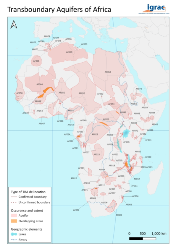
A new regional transboundary aquifer map for the African region has been released. It is based on the Transboundary Aquifers of the World Map (TBA Map) that was updated in 2021 and showcases the occurrence and extent of Transboundary Aquifers across the African continent. Globally there are now 468 transboundary aquifers and aquifer systems identified, underlying almost every nation. Across Africa, there are now 106 transboundary aquifers, an increase from 72 in the 2015 inventory. They range in size from 10 km2 (AF108) to 2,500,000 km2 (AF063).
A significant source of information when updating the transboundary aquifer inventory for the Africa region was data collected as part of the SADC Groundwater Management Institute (SADC-GMI) Sustainable Groundwater Management project and through the Scottish Governments Climate Justice Fund Water Futures Programme (CJF).
Sustainable Groundwater Management in SADC Member States: Eastern Kalahari Karoo Basin
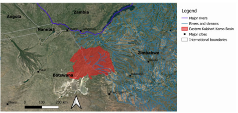
SADC-GMI, through the GEF and World Bank funded project “Sustainable Groundwater Management in SADC Member States”, undertook research in the Eastern Kalahari-Karoo Basin Transboundary Aquifer (EKK-TBA) shared between Botswana and Zimbabwe. The key objective of this research was to provide a basis for enhancing and strengthening the understanding of and establish a platform for joint management in the EKK-TBA. During this project, the delineation of the EKK-TBA was improved. The improved delineation and the increased understanding of this transboundary aquifer will assist in enhancing cooperation over groundwater resources management between riparian member states.
Climate Justice Fund Water Futures Programme
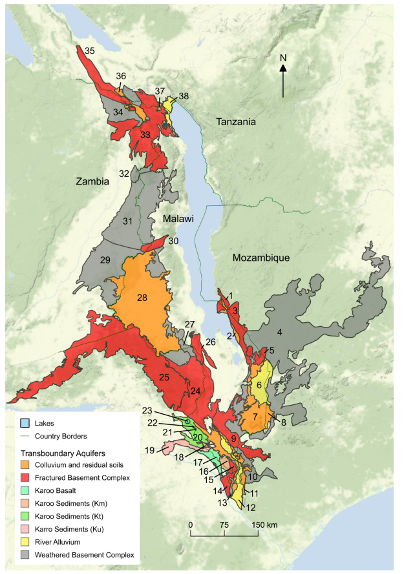
The “Climate Justice Fund: Water Futures Programme” was funded through the Scottish Government with the aim of the developing of a programme of integrated water resource management (IWRM) in Malawi. Part of this project focused on the assessment and management of transboundary aquifers shared between Malawi. This work was carried out by Christina Fraser (now IGRAC Groundwater Specialist) during her PhD.
In total, 38 transboundary aquifer units of local to national importance were identified as being shared between Malawi and its neighbouring countries using a detailed hydrogeological-based methodology. This is an increase from the previous 3 recorded in IGRACs 2015 inventory from the Transboundary Waters Assessment Programme, demonstrating the complexity often lost in regional scale assessments. However, more work will need to be done to investigate the connectivity and groundwater flow systems of these aquifer units. This research will assist Malawi and neighbours in prioritizing which transboundary aquifers to focus further assessment and cooperative efforts towards.
More progress is needed
Despite the progress made, there are still data and knowledge gaps for Africa’s transboundary aquifers. Many of the delineations are still estimated, shown on the map as ellipses (e.g. AF011 Save Alluvial Aquifer, AF072 Rift Aquifer and AF045 Shabelle Aquifer). These aquifers require further assessment to confirm their extent. Several aquifer boundaries are also unconfirmed by all riparian states (e.g. AF069 Northwest Sahara Aquifer System, AF008 Limpopo Basin Aquifer and AF053 Baggara Basin). This could lead to a lack of ownership over their assessment, monitoring and management by riparian’s and likely impacts SDG 6.5.2 reporting on water cooperation. In these cases, it will be important to enter into a dialogue with member states to agree upon and confirm aquifer boundary locations.

A recently identified example of the need for further transboundary aquifer assessment across Africa is the case of the Afar Rift Valley/Afar Triangle transboundary aquifer. Highlighted in a report by the International Centre for Water Cooperation, the exact location, size and extent of this aquifer is still unknown. However, it could be supplying groundwater to a well field close to the border between the countries of Djibouti and Ethiopia. This well field is an essential source of water in the drought-prone region and groundwater is pumped and piped from the site in Ethiopia to Djibouti as part of a water sharing agreement.
It is clear that more research and assessment is required in the area to determine if the well field is indeed being supplied by the transboundary aquifer. This is essential to understand the aquifer system in more detail to ensure that water supplies are safeguarded for the future through suitable management and governance.
References:
- Fraser, C.M., Kalin, R.M., Kanjaye, M., Uka, Z. 2020. A National Border-Based Assessment of Malawi’s Transboundary Aquifer Units: Towards Achieving Sustainable Development Goal 6.5.2. Journal of Hydrology: Regional Studies.Volume 31, October 2020, 100726. DOI: https://doi.org/10.1016/j.ejrh.2020.100726;
- Grönwall, J. 2022. Safeguarding shared interests through cross-border cooperation and transboundary aquifers: A case study of the Ethio-Djibouti Transboundary Water Project and the Afar Rift Valley/Afar Triangle Aquifer. Stockholm: International Centre for Water Cooperation and SIWI;
- IGRAC (International Groundwater Resources Assessment Centre), 2021. Transboundary Aquifers of the World [map]. Edition 2021. Scale 1: 50 000 000. Delft, Netherlands: IGRAC, 2021;
- IGRAC (International Groundwater Resources Assessment Centre), 2022. Transboundary Aquifers of Africa [map]. Edition 2022. Delft, Netherlands; and
- SADC-GMI, 2020. Transboundary Diagnostic Analysis of the Eastern Kalahari-Karoo Basin Aquifer system. SADC-GMI report: Bloemfontein, South Africa.