


By: Alexia Calvel
The intensification of climate-related disasters is calling for the development of contextualised early warning systems (EWS) adapted to people’s needs. In this context, impact-based forecasting has been pushed as the de facto EWS approach to use for translating forecasting information into information adapted to local conditions and local needs.
The output permits to define risk levels and action measures to take from local to national level. However, even if forecasting of weather events has improved, the associated impacts are yet not clearly identified limiting the ability to assess risk and take appropriate actions. As the IFRC mentions “Early warning systems are only as good as the actions they catalyse”, impact assessments are thus an urgent gap to fill to improve disaster preparedness.
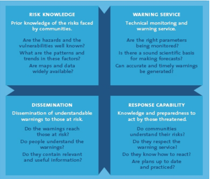
The design of an early warning systems relies on four key elements, covers early warning to early action, and aims to enable end-users to take timely protective actions against hazardous events:
- Risk knowledge;
- Warning service;
- Dissemination; and
- and response capability.
This system has been developed to mainly address natural related hazards such as droughts, floods, famine, earthquakes, hurricanes, tsunamis etc. Groundwater early warning systems also exist but they remain isolated from the common EWS and tend to focus primarily on pollution. Details on the four components of an EWS are provided in Figure 1.
Drought early warning systems
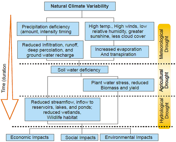
Droughts are context specific hazards and are characterised by four types (Fig. 2):
- Meteorological drought: relating to a lack of precipitation;
- Hydrological drought: relating to low water supply from streams, reservoirs, and groundwater;
- Agricultural drought: relating to a lack of precipitation that has resulted in crop failure; and
- Socioeconomic drought: relating to a lack of precipitation that has affected the supply and demand of various commodities.
This natural phenomenon has caused disastrous impacts on the livelihoods of the population worldwide which has led to development of Drought Early Warning Systems (DEWS) as mitigation measures. However, their slow – onset nature is creating difficulties to predict them and to identify the impacts they provoke. Furthermore, the wide range of definitions and the lack of clarity on the impacts of this hazard, is causing drought perceptions to differe adding to the perplexity to assess this hazard and develop adapted mitigation plans and adapted drought early warning systems.
Different types of drought early warning systems have thus developed to answer to local contexts. Examples from Europe and in Eastern Africa are described and potential solutions for the integration of groundwater are discussed.
Examples of Drought Early Warning Systems
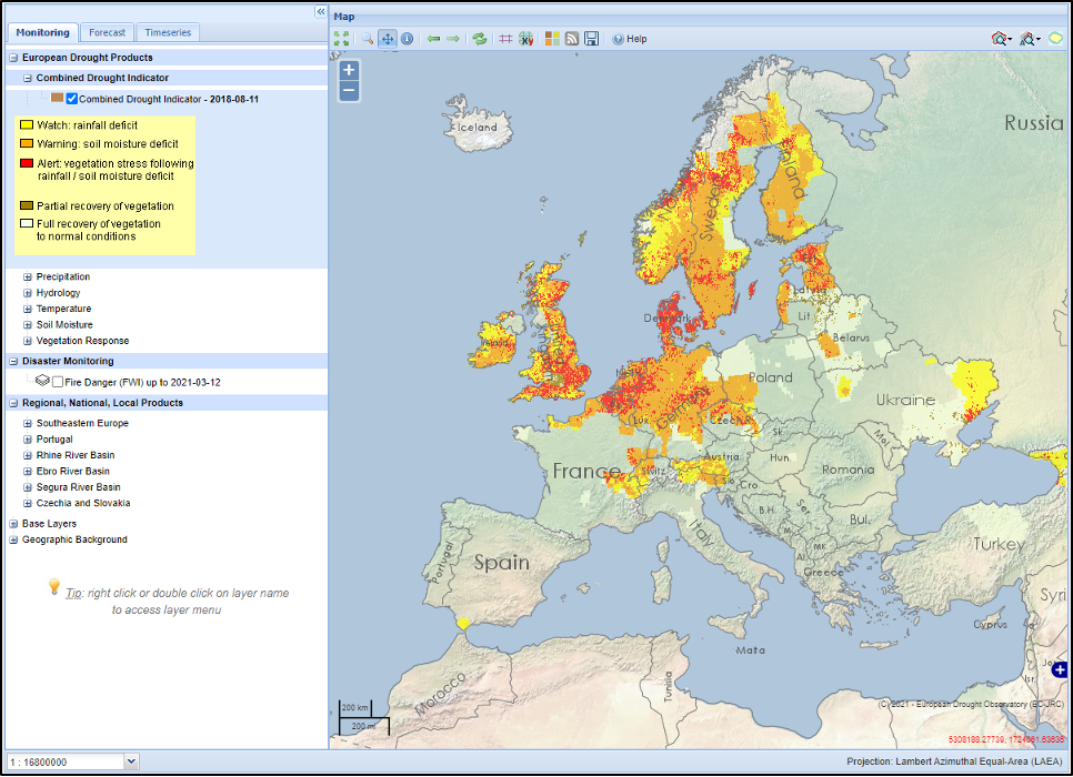
In Europe, the European Drought Observatory (EDO) is a service run by the European Commission’s Joint Research Centre (Fig. 3). Several indicators representing precipitation, soil moisture, river flow and vegetation water stress are used to generate drought information and warning:
- Standardised Precipitation Index (SPI): This indicator measures anomalies of accumulated precipitation during a given period, and is the most commonly used indicator for detecting and characterising meteorological droughts;
- Standardised Snowpack Index (SSPI): This indicator measures anomalies of daily soil moisture (water) content, and is used to measure the start and duration of agricultural drought conditions;
- Soil Moisture Anomaly (SMA): This indicator is used for determining the start and duration of agricultural drought conditions, which arise when soil moisture availability to plants drops to such a level that it adversely affects crop yield, and hence, agricultural production;
- Anomaly of Vegetation Condition (FAPAR Anomaly): This indicator measures anomalies of satellite-measured FAPAR (Fraction of Absorbed Photosynthetically Active Radiation), and is used to highlight areas of relative vegetation stress due to agricultural drought;
- Low-Flow Index (LFI): This indicator, which is derived from daily river discharge outputs produced by the JRC’s in-house hydrological rainfall-runoff model (LISFLOOD), is used for near real-time monitoring of hydrological streamflow drought at European scale;
- Heat and Cold Wave Index (HCWI): This indicator is used to detect and characterise extreme temperature anomalies, such as heat waves (during the warm season) and cold waves (during the cold season), and is computed based on daily minimum and maximum temperatures; and
- Combined Drought Indicator (CDI): This indicator integrates information on anomalies of precipitation, soil moisture and satellite-measured vegetation condition, into a single index that is used to monitor both the onset of agricultural drought and its evolution in time and space.
Even though, various indicators have been developed to represent the hydrological cycle, forecasting information is not translated into relevant information adapted to end-users, and indicators to represent the groundwater component are lacking.
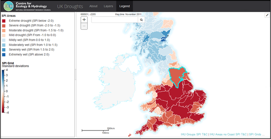
In the UK, similarly to the Netherlands, the drought early warning system comes in the form of decentralized drought mitigation decisions. The national regulators and environmental agency, together, require all those who are (ground)water users to have a plan that aligns with general national guidelines. Operators then define their own triggers and drought mitigation action plans, including when relevant groundwater impacts. Currently, the UK drought portal (Fig.4) assesses drought conditions based solely on precipitation datasets (SPI index) and is used as an awareness tool. Information on evaporation rates, or river flow and groundwater conditions are not provided. However, other sources of information are available and provide assessment on the hydrology and water situation in the country. In addition, a National Drought Group has been formed to enhance effective collective action towards drought. This group is composed of governments departments, water companies, environmental groups, and other relevant stakeholders.
In Eastern Africa, droughts cause tremendous impacts on the agricultural sector, which has led to the development of user-centric seasonal forecasts through national hydrogeological and meteorological services, as a form of drought early warning system. However, this practice has been promoted to answer to food security and not water security. Indeed, water supply is assumed to be accessible by everyone although water demand in Africa is increasing. In Kenya, the seasonal forecast produced is mainly based on precipitation, temperature, and vegetation indices (Fig. 5) at national scale and then downscale at the county level with action plans being also decentralised at county levels. Based upon climate prediction drought warnings are issued and provide agricultural advices such as type of crops to plant or locust information to enhance crop production. Post-season, there is also a drought early warning system based on the monitoring of mainly soil moisture, vegetation, precipitation, and temperature. Based upon these results different warning levels from 'Normal', 'Alert', 'Alarm' to 'Emergency' are established.
However, recently impacts of droughts have been recognized to extend to other sectors, leading to a focus on water access and the role of groundwater. In fact, the government of Kenya has launched an initiative to investigate potential places where groundwater would be available to supply population during emergencies. But, due to a lack of funds and capacity the exploration on groundwater and monitoring of existing wells remains poor. In Ethiopia, such as in Kenya, the drought early system has been developed to answer to food security. Nevertheless, since the last drought in 2015, water access has been recognized as being also severely impacted. In response, the government of Ethiopia with the support of UNICEF also took an initiative in 2015 to integrate water resources in drought responses by assessing the amount of people that have access to water supply, in the whole country. Groundwater represents a key water resource in the context of Eastern Africa; however data are poorly available, limiting the possibility to identify groundwater impacts essential for effective drought action.
The potential place of groundwater within drought early warning systems
When a drought occurs, there is a need to know who is affected and where water can be found and used. Drought forecasting indicators have thus been developed to assess different components of the hydrological cycle. The most common parameters used relate to precipitation, soil moisture and vegetation indexes. Hydrological forecasting is considered in certain regions but poorly used worldwide. As for groundwater, even if it is considered as an indicator for hydrological drought it is often not taken into consideration, even for highly groundwater-dependent regions. During emergencies though, groundwater is considered the de facto water supply. Interestingly enough, it is considered a reliable buffer resource even if it remains poorly understood and unsustainably managed. In certain countries, the lack of groundwater monitoring systems, and technical capacity is causing this resource to be overlooked and not explored, though used for water supply purposes. In other countries, despite the availability of groundwater data, gaps remain in translating monitoring data into information relevant to end-users, and in identifying groundwater impacts and interlinkages with the socio-economic and ecological systems.
The poor understanding of groundwater systems and associated impacts exclude the possibility from a potential integration within on-going drought early warning systems. Assessing groundwater resources is therefore elementary to determine groundwater potential for drought mitigation and enable an integration in already established DEWS. Anticipation of groundwater impacts and groundwater potential are key to identify possibilities for the communities and improve drought early action.
An identification of drought plans, and affected users’ needs to be clearly realized, in order to align groundwater data to these actions and support early actions. As expressed by the IFRC, the effectiveness of an early warning system does not rely solely on forecasting but also on the actions they catalyze, groundwater impacts and dependencies require thus clarification. Where data are available, there is a necessity to assess where groundwater sits and the information on groundwater that would be useful for the action to take. In addition, and as initiated by UPGro, information must be made available in the most appropriated way and translated to answer to groundwater users. The presence of groundwater monitoring does not necessarily imply that information is adapted to end-users, work to design people-centered monitoring systems are the next steps to follow to improve drought response.
In countries where limited data are available, groundwater monitoring in affected areas shall be in addition advocated for to ensure water supply for affected people in the most optimal way. Communities’ decision-making processes during droughts is also an elementary aspect that must be evaluated to improve their living conditions and provide useful groundwater information.
Such assessments are urging as drought impacts intensify and start affecting groundwater supply. Groundwater’s buffer capacity is thus losing its suitability to mitigate impacts, and to the contrary could potentially become a hazard and cause long term impacts on the population.
Acknowledgements
- Alan MacDonald - Professor, Principal Hydrogeologist, BGS - UK
- Daniel Olago - Professor and Director, Institute for Climate Change and Adaptation, University of Nairobi – Kenya
- David A Macleod - Senior Research Associate, University of Bristol – UK
- Declan Conway - Professorial Research Fellow, Grantham Research Institute – UK
- John Bloomfield - Groundwater Sustainability team leader, BGS - UK
- Karen Villholth - Principal Researcher and Coordinator, Groundwater, IWMI - South Africa
- Katharine Vincent - Director Kulima Integrated Development Solutions (Pty) Ltd, South Africa
- Marc van den Homberg - Scientific Lead of 510 Global, The Netherlands Red Cross - the Netherlands
Sources
- Akvo (2015). Government of Ethiopia and UNICEF compile national water & sanitation inventory. Retrieved from https://akvo.org/blog/government-of-ethiopia-and-unicef-compile-national-water-sanitation-inventory/;
- Bode, F., Nowak, W. & Loschko, M. Optimization for Early-Warning Monitoring Networks in Well Catchments Should Be Multi-objective, Risk-Prioritized and Robust Against Uncertainty. Transp Porous Med 114, 261–281 (2016). https://doi.org/10.1007/s11242-015-0586-6;
- Calow, Roger & Macdonald, Alan & Nicol, Alan & Robins, Nick. (2009). Ground Water Security and Drought in Africa: Linking Availability, Access, and Demand. Ground water. 48. 246-56. 10.1111/j.1745-6584.2009.00558.x.;
- Calvel, A., Werner, M., Van den Homberg, M., Cabrera Flamini, A., Streefkerk, I., Mittal, N., ... & Boyce, C. (2020). Communication structures and decision making cues and criteria to support effective drought warning in Central Malawi. Frontiers in Climate, 2, 16. https://doi.org/10.3389/fclim.2020.578327;
- Christel Prudhomme, Jamie Hannaford, Shaun Harrigan, David Boorman, Jeff Knight, Victoria Bell, Christopher Jackson, Cecilia Svensson, Simon Parry, Nuria Bachiller-Jareno, Helen Davies, Richard Davis, Jonathan Mackay, Andrew McKenzie, Alison Rudd, Katie Smith, John Bloomfield, Rob Ward & Alan Jenkins (2017) Hydrological Outlook UK: an operational streamflow and groundwater level forecasting system at monthly to seasonal time scales, Hydrological Sciences Journal, 62:16, 2753-2768, DOI: 10.1080/02626667.2017.1395032;
- CAS (2021). Climate Adaptation Summit 2021, 25-26 JANUARY 2021 – ONLINE WORLDWIDE. Retrieved From https://www.cas2021.com/;
- European Drought Center. Retrieved from https://www.geo.uio.no/edc/droughtdb/;
- European Drought Observatory (2021). Map of Current Droughts in Europe. Retrieved from https://edo.jrc.ec.europa.eu/edov2/php/index.php?id=1052;
- GOV.UK (2020). National Drought Group – July 2020 statement. Retrieved from https://www.gov.uk/government/news/national-drought-group-july-2020-statement;
- Groundwater Early Warning System for the South of Madagascar. WASH Fact Sheet, 2019. UNICEF. Retrieved from https://www.unicef.org/madagascar/media/1321/file/WASH%20Technical%20note%20GEWS%20ECHO.pdf;
- Groundwater For Emergency Situations – A methodological Guide. IHP-VII Series on Groundwater No. 3. UNESCO (2011). Retrieved from: https://www.uncclearn.org/wp-content/uploads/library/unesco_meth_guide.pdf;
- IFRC (n.d.). Drought preparedness and response in the arid and semi-arid lands of Ethiopia, Kenya and Uganda, and in the East Africa Region. (n.d.). Early Warning Early Action Brief. Retrieved from https://www.ifrc.org/PageFiles/113913/Early%20Warning%20Early%20Action%20Report.pdf;
- IPCC (2019). Climate Change and Land. Retrieved from: https://www.ipcc.ch/site/assets/uploads/2019/08/4.-SPM_Approved_Microsite_FINAL.pdf;
- Luther, J., Hainsworth, A., Tang, X., Harding, J., Torres, J., and Fanchiotti, M. (2017). World Meteorological Organization (WMO)—Concerted International Efforts for Advancing Multi-hazard Early Warning Systems. Llubjana: Springer. doi: 10.1007/978-3-319-59469-9_9;
- MacAllister, D.J., MacDonald, A.M., Kebede, S. et al. Comparative performance of rural water supplies during drought. Nat Commun 11, 1099 (2020). https://doi.org/10.1038/s41467-020-14839-3;
- Macdonald, Alan & Bell, Rachel & Kebede, Seifu & Azagegn, Tilahun & T, Yehualaeshet & F, Pichon & Young, Matthew & Mckenzie, A. & Lapworth, Dan & Black, Emily & RC, Calow. (2019). Groundwater and resilience to drought in the Ethiopian Highlands. Environmental Research Letters. 14. 10.1088/1748-9326/ab282f;
- Mahon, R., Greene, C., Cox, S.-A., Guido, Z., Gerlak, A. K., Petrie, J.-A., et al. (2019). Fit for purpose? Transforming national meteorological and hydrological services into National Climate Service Centers. Clim. Serv. 13,14–23. doi: 10.1016/j.cliser.2019.01.002;
- Monacelli, G., Galluccio, M. C., and Abbafati, M. (2005). Drought Within the Context of the Region VI. Available online at: http://www.wmo.int/pages/prog/hwrp/documents/regions/DOC8.pdf;
- Mungai, C. (2017). Developing User-Centric Climate Services to Enhance Drought Resilience in Africa. Available online at: https://ccafs.cgiar.org/blog/developing-user-centric-climate-services-enhance-drought-resilienceafrica#.XnSqYPlKiUn;
- NDMA (n.d). Committed to Ending Drought Emergencies. Retrieved from https://www.ndma.go.ke/index.php/resource-center/early-warning-reports;
- NDMC (n.d.). Types of Drought. Retrieved from https://drought.unl.edu/Education/DroughtIn-depth/TypesofDrought.aspx;
- Pulwarty, R. S., and Sivakumar,M. V. K. (2014). Information systems in a changing climate: early warnings and drought risk management. Weather Clim. Extrem.3, 14–21. doi: 10.1016/j.wace.2014.03.005;
- Roudier, P., Muller, B., d’Aquino, P., Roncoli, C., Soumaré, M. A., Batté, L., and Sultan, B. (2014). The role of climate forecasts in smallholder agriculture: lessons from participatory research in two communities in Senegal. Clim. Risk Manag. 2, 42–55. doi: 10.1016/j.crm.2014.02.001;
- Shivakoti, B.R.; Villholth, K.G. et al. Strategic use of groundwater-based solutions for drought risk reduction and climate resilience in Asia and beyond. Contributing Paper to GAR 2019. Retrieved from https://www.undrr.org/publication/strategic-use-groundwater-based-solutions-drought-risk-reduction-and-climate-resilience;
- Sivakumar, M. V. K. (2006). Dissemination and communication of agrometeorological information–global perspectives. Meteorol. Appl. 13(Suppl.1), 21–30. doi: 10.1017/S1350482706002520;
- Taylor, A. L., Kox, T., and Johnston, D. (2018). Communicating high impact weather: improving warnings and decision making processes. Int. J. Disast. Risk Reduct. 30, 1–4. doi: 10.1016/j.ijdrr.2018.04.002;
- Thames Water (n.d.). Our drought plan. Retrieved from https://www.thameswater.co.uk/about-us/regulation/drought-plan;
- UK Centre for Ecology & Hydrology (n.d.). Droughts. Retrieved from https://eip.ceh.ac.uk/droughts;
- UK Centre for Ecology & Hydrology (n.d.). Hydrological Outlook UK. Retrieved from https://www.hydoutuk.net/;
- UNISDR (2015). Sendai Framework for Disaster Risk Reduction 2015 - 2030. Retrieved from https://www.unisdr.org/we/inform/publications/43291;
- UPGro – African Groundwater 2020 (2020). UPGro Science: Knowledge sharing approaches, such as RAINWATCH and Farmer Radio, can be used to increase resilience by communicating climate and groundwater forecasts with farmers. Retrieved from https://upgro.org/2020/06/30/upgro-science-knowledge-sharing-approaches-such-as-rainwatch-and-farmer-radio-can-be-used-to-increase-resilience-by-communicating-climate-and-groundwater-forecasts-with-farmers-s12/;
- USGS (n.d.). Groundwater and Drought. Retrieved from https://water.usgs.gov/ogw/drought/;
- Villagrán de León, J. C., Pruessner, I., and Breedlove, H. (2013). Alert and Warning Frameworks in the Context of Early Warning Systems. A Comparative Review. Bonn: United Nations University Institute for Environment and Human Security. Retrieved from: https://www.droughtmanagement.info/literature/UNU-EHS_alert_warning_frameworks_ews_2013.pdf;
- Villholth, K.G., Tøttrup, C., Stendel, M. et al. Integrated mapping of groundwater drought risk in the Southern African Development Community (SADC) region. Hydrogeol J 21, 863–885 (2013). https://doi.org/10.1007/s10040-013-0968-1;
- Villholth, K.G. 2009 IOP Conf. Ser.: Earth Environ. Sci. 6 292062. Retrieved from: https://www.researchgate.net/publication/252872834_The_neglected_role_of_groundwater_in_climate_change_adaptation_and_disaster_risk_reduction;
- Vrba, J. The role of groundwater governance in emergencies during different phases of natural disasters. Hydrogeol J 24, 287–302 (2016). https://doi.org/10.1007/s10040-015-1353-z;
- Vrba, J., Renaud, F.G. Overview of groundwater for emergency use and human security. Hydrogeol J 24, 273–276 (2016). https://doi.org/10.1007/s10040-015-1355-x;
- Wilhite, D. A. (2000). “Chapter 1: Drought as a natural hazard: concepts and definitions,” in Drought: A Global Assessment, Vol. 1 ed D. A.Wilhite (London: Routledge), 3–18; and
- WMO (2018). Multi-hazard Early Warning Systems: A Checklist. Available online at: https://library.wmo.int/index.php?lvl=notice_displayandid=20228#.XiAz1_lKiUl.